
oceanographic exploration
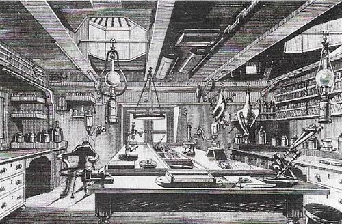
Figure 1. The natural history laboratory aboard HMS Challenger was fitted for the study of marine, bird, and island life. The first true oceanographic ship, Challenger was a converted man-of-war and this laboratory was installed on her gun deck and lit by a gunport.
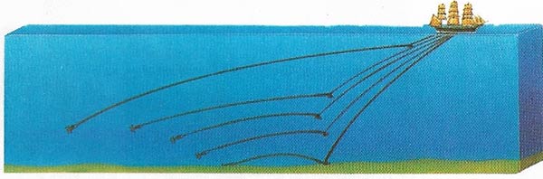
Figure 2. Dredging on the Challenger expedition was a slow, tedious operation and was nicknamed drudging by the crew who failed to share the enthusiasm of the scientists. The dredge was streamed out at the end of a warp and was made to sink by the attachment of a sliding weight.
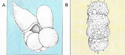
Figure 3. The first world map of marine sediments was provided by the Challenger expedition. Vast areas of the seafloor were found to consist of dead shells of single-celled animals (mainly Foraminifera and radiolarians) and algae (diatoms). Foraminifera, such as Globigerina digitata (A), have calcareous shells whereas radiolarians, such as Panartus tetrathalamus (B), have siliceous shells. The Challenger discovered 3,508 new species of radiolarians.
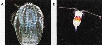
Figure 4. The Challenger expedition also studied the species and individuals forming plankton, such as the comb jelly (A), and ctenophore and the copepod (B), a crustacean.
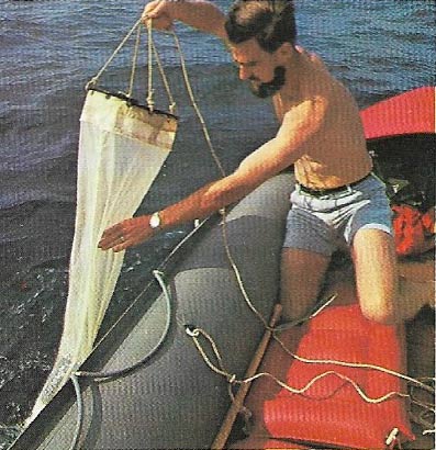
Figure 5. The plankton net is a cone of fine muslin kept open by a hoop and weighted by a sinker on its bridle. The small end is tied to the neck of a jar in which the plankton is collected.

Figure 6. The Nansen bottle is used for taking deep-water samples. Bottles are attached at suitable intervals on the hydrographic wire (1). When the desired depth is reached a messenger weight (2) is slid down until it hits the latch (3) of the uppermost bottle which then swings around its lower grip, closing the valves (4) and tripping the thermometers (5). The messenger then slides farther down the wire (6) and trips the lever (7), releasing a new messenger to operate the next bottle down.
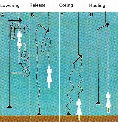
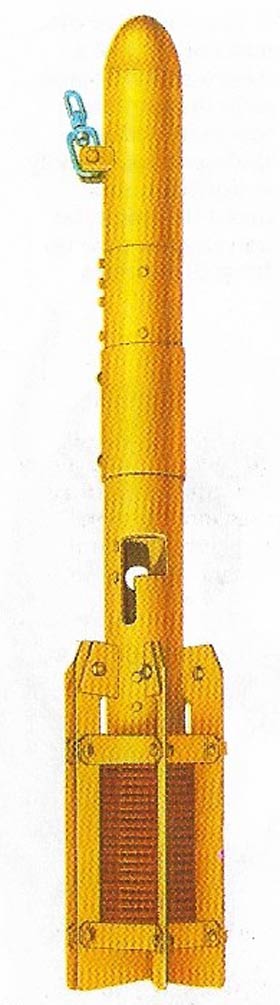
Figure 7. The gravity corer, which takes samples off the seafloor sediments, consists of a metal tube (1) with a lead weight (2) and a tripping device device (3). The instrument is lowered in the sea (A) with the lower part of the wire coiled (4). When the tripping device touches the bottom (B) the coil is released and the core barrel falls and punches into the sediments (C). It is then brought back to the surface (D),
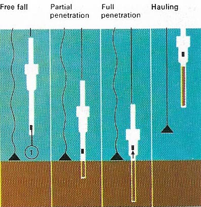
Figure 8. The piston corer is an improvement on the gravity corer. Its penetration is increased by an internal piston (1) which sucks the corer deeper into the sediment. Piston cores can exceed 20 meters (60 feet) in length whereas gravity cores seldom exceed 2 meters (6 feet).
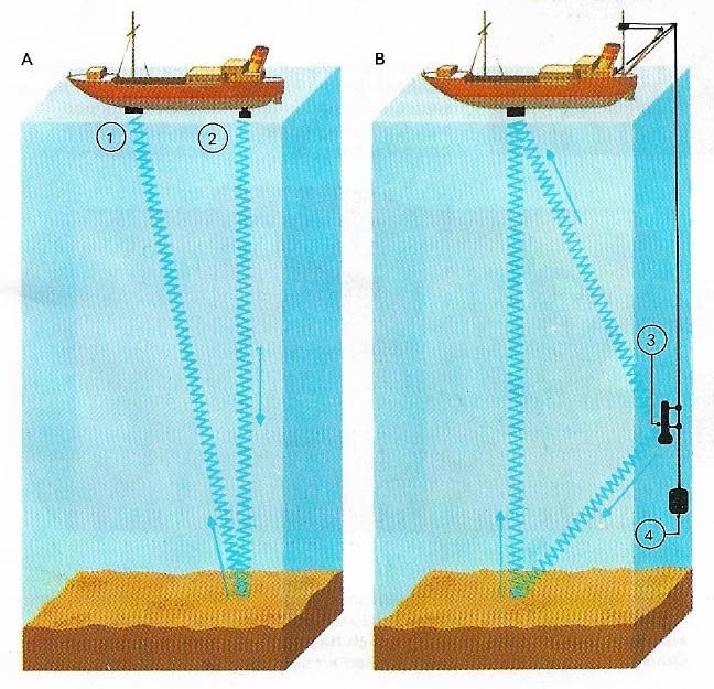
Figure 9. Echo-sounding is a method of measuring depth from speed of sound in seawater – the lapse is timed between sending a sound signal and receiving its echo which has bounced off the bottom. In A both the sound receiver (1) and the transmitter (2) are on the ship, and the water depth is measured. In B a transmitter (3), weighted by a sinker (4) sends signals direct to a single receiver and bounces others off the bottom to calculate the depth.
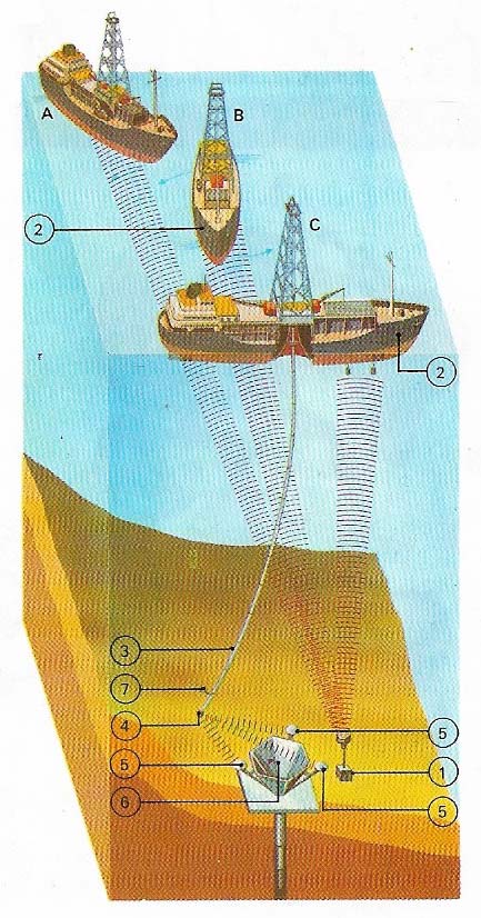
Figure 10. The deep-sea drilling vessel Glomar Challenger maintained its station by dynamic positioning; the drift of the ship is computed relative to a sonar beacon (1) and is automatically corrected (A, B, C) by side thrusters (2) and the main propeller. After a worn drill bit at the end of the drill string (3) is renewed, the string is guided back to the hole by fitting the core barrel with a sonar device (4), which determines its position relative to three sonar reflectors (5) placed around the re-entry funnel (6). The drill is then guided into the funnel by a sideways jet (7).
The topography of the ocean floor is hardly more familiar to man than that of the hidden side of the moon. Much remains to be discovered about the oceanic two-thirds of our planet and oceanographic research is not just a matter of scientific curiosity – we are only just beginning to appreciate and to exploit the vast untapped food, mineral, and energy resources of the sea.
Early observations
The earliest scientific observations of the sea were recorded by Aristotle (384–322 BC) who described 180 marine animal species. Little further progress was made until the age of discovery during the fifteenth and sixteenth centuries which advanced the geographical knowledge of the seas and their currents. In 1670 the Irishman Robert Boyle (1627–1691) published his Observations and Experiments on the Saltiness of the Sea in which he correctly deduced that the salt is derived from the weathering of the land. He introduced the silver nitrate test to measure the chloride content of seawater, a method which is still used today.
The Italian count Luigi Marsigli (1658–1730), a contemporary of Boyle, deserves to be called the first oceanographer because he studied the whole realm of the sea, from its flora and fauna to its currents. He invented the propeller current meter and discovered the deep counter-current in the Bosporus, correctly attributing it to differences in salinity between the Black Sea and the Mediterranean. (The Black Sea receives more water from rivers than it loses through evaporation, hence the main surface current flows towards the Mediterranean.)
In the eighteenth century the American Benjamin Franklin (1706–1790) published a chart of the Gulf Stream which successfully shortened the passage time of the mail packets between North America and England. James Cook (1728–1779), during his famous Pacific voyages from 1768 to 1779, finally exploded the geographical myth of a great southern continent in the South Pacific where he took soundings down to 1,243 meters (4,078 feet) which hinted at even greater depths.
At the very beginning of the nineteenth century the German Alexander von Humboldt (1769–1859) described the cold cur-rent that flows up the Andean coast to the Galapagos Islands. In 1835 the English naturalist Charles Darwin (1809–1882) visited these islands during his round-the-world voyage in HMS Beagle. Darwin made many sea-related observations, including some on plankton (the microscopic life forms of the sea). He also proposed a theory on the origins of coral reefs which after more than a century of heated debate was finally proved correct by the well-drilling on Eniwetok atoll in 1952. In the middle of the 19th century, Lieutenant Matthew Fontaine Maury of the US Navy (1806–1873) published Wind and Current Charts, the first pilot charts, compiled from the data in ships' log books.
The Challenger expedition
The findings of the early scientists and the many unanswered questions they posed induced the British Government in 1872 to finance a scientific expedition to circumnavigate the world, for which the Royal Navy provided a ship – HMS Challenger.
Challenger, under the scientific direction of Charles Wyville Thomson (1830–1882), sailed 69,000 nautical miles between 1872 and 1876. Among other observations, ocean depths and surface currents were measured, water samples taken for analysis and sea life was dredged or trawled (Figure 2). The ship was also fitted with laboratories (Figure 1). The Challenger expedition outlined the broad features of the seafloor and the nature of its sediments, and discovered some 4,417 new species of animals and plants. It also showed that life existed in the most extreme depths. Thus modern oceanography began.
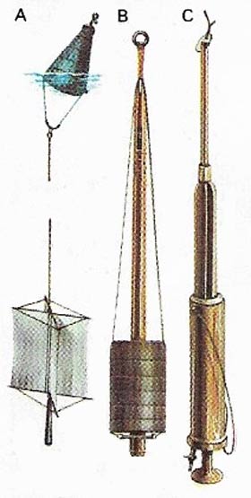 |
| Instruments used on the Challenger included a current drag (A), which was lowered to a predetermined depth, the drift being shown at the surface by a buoy. The Baillie sounding machine (B) measured depth and collected samples of sediment. The slip water bottle (C) was used for sampling the bottom water for in-board analysis. |
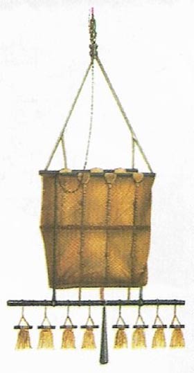 |
| This dredge was used on the Challenger for collecting biological specimens from the seafloor. |
Modern oceanography
Many expeditions were to follow using improved techniques and instruments. The Norwegian polar explorer Fridtjof Nansen (1861–1930) invented the deep-water sampling bottle (Figure 6) that bears his name. It can carry thermometers for determining the temperature at depth. Plankton nets (Figure 5) were perfected and many ingenious instruments, such as the bathythermograph, were invented. A breakthrough came with the discovery of echo-sounding (Figure 9) just before World War I, but it was only perfected for use at great depths after World War II.
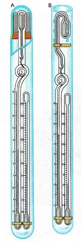 |
| Deep-sea reversing thermometers (DSRT) are fixed on Nansen bottles. The protected thermometer (A) is insulated from pressure and records the temperature when the bottle is tripped. The unprotected thermometer (B) is similar but the hydrostatic pressure squeezes the reservoir so that the reading is a function of both temperature and depth. The small auxiliary thermometers indicate the temperature at the time of the reading and this must be introduced as a correction. |
 |
| The bathythermograph simultaneously records temperature and depth down to 300 meters (1,000 feet) but it lacks the precision and the depth range of the DSRT. |
A new era in marine geosciences was introduced in 1961 by the Mohole project on the US drilling ship CUSS (from the initials of the participating oil companies). The aim to drill down to the earth's mantle was not achieved, but the accumulated experience was put to use in the American Deep Sea Drilling Project that started in 1968. This project confirmed the seafloor spreading theory, which states that new seafloor is generated along the mid-oceanic ridges.
The emphasis in oceanography has changed since the early days when the main object was to collect samples of sediment, water and marine life. While this is still part of the research, the aims are increasingly to find new food and physical resources (minerals and energy), to control pollution and to conserve the biological resources of the sea. Oceanography has become an advanced science involving satellite navigation, expensive ships with onboard computers and laboratories and backed up by sophisticated shore-based facilities.

