
canal
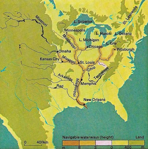
Figure 1. The river systems of the Mississippi and Ohio form one of the largest in the world. Their basins cover two-thirds of the United States. Many of the rivers are navigable and canals have been built to connect other waterways, extending the system to provide a continuous water route from New Orleans in the south to Chicago and the St Lawrence Seaway, and via the Ohio River direct to New York. Pittsburgh and Philadelphia were also in the 19th-century canal network, which connected with both the Columbia River and Chesapeake Bay. There is also a link from New York direct to the St Lawrence.
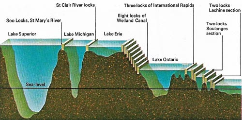
Figure 2. The St Lawrence Seaway provides a 3,830 kilometers (2,380 miles) inland route for ocean-going ships from the Atlantic to the heart of Canada and the United States. From Montreal it rises 51.5 meters (169 feet) to Lake Ontario via two small lakes, three canals, and seven locks. Between Lake Ontario and Lake Erie the waterway bypasses the Niagara Falls rising 98 meters (322 feet) in 45 kilometers (28 miles) through the eight locks of the Welland Ship Canal. From Lake Erie the route passes via Detroit and the St Clair River and lake into Lake Huron. This lake connects directly with Lake Michigan, via the Mackinac Strait, so linking the port of Chicago with the sea. The St Mary;s Falls, between the northern point of Lake Huron and Lake Superior, are passed by a canal with five locks. This section is icebound in winter.
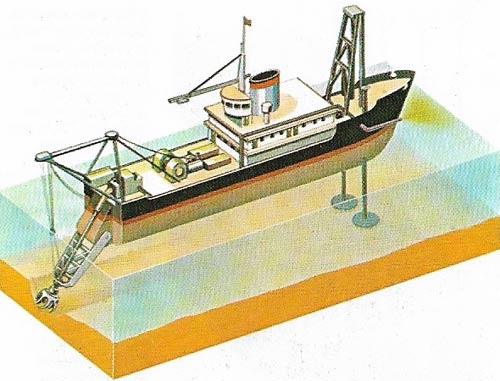
Figure 3. The depth o fa shipping canal must be rigorously maintained to ensure that ships do not ground, causing delay not only to themselves but to all shipping along the length of the water channel. Dredgers of many types are use. This cutter dredge has a tin-leg bracing system to resist the action of the rotary cutter. A suction pipe draws off the debris and discharges it away from the vessel or into a barge moored alongside.
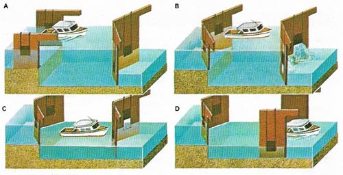
Figure 4. Passing down a lock, a vessel first enters it from the higher level (A) and the gates are shut behind it. Sluices in or around the lower gates are then opened (B), allowing water from the lock to pass to the lower level, lowering the water level and with it the floating vessel. When the lock level equals the lower canal level (C), the lower gates are opened (D). Sluices in or around the upper gates are used to raise the lock level whenever a vessel passes up the canal.
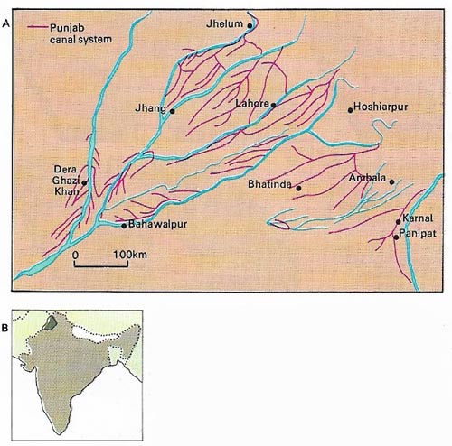
Figure 5. A system of irrigation canals in western Punjab (A), constructed by British engineers, was one of the major engineering achievements of the 19th century. These were running water canals fed from the River Indus and the tributaries by building great masonry barrages. They turned an arid area half the size of England into northern India's most fertile food-producing region (B).
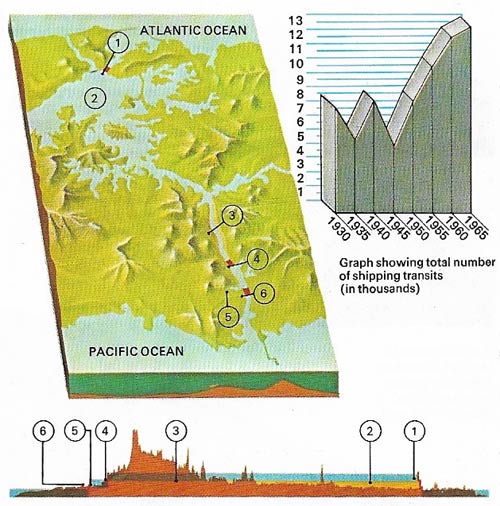
Figure 6. The Panama Canal links the Atlantic and Pacific oceans, enabling ships that are less than 306 meters (1,000 feet) long, 34 meters (112 feet) in the beam, and have a draft of less than 12 meters (40 feet) to avoid the voyage around South America. From the Atlantic an 11 km (7 mile) sea-level stretch ends at the Gatun Locks (1) leading to Lake Gatun (2), 26 meters (85 feet)above sea-level. The route then runs 38 kilometers (24 miles) across Lake Gatun, along the Gaillard Cut (3) to the Pedro Miguel Lock (4) and Miraflores Lake (5), 16 meters (53 feet) above sea-level. Finally the Miraflores Locks (6) drop down to sea-level and lead to the Pacific Ocean.
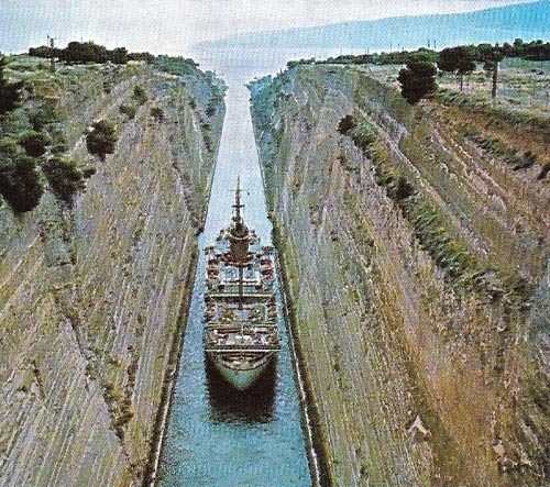
Figure 7. A massive excavation 5.6 kilometers (3.5 miles) long was made in 1893 across the isthmus at Corinth to link the Ionian and Aegean seas. The Corinth ship canal has no locks, the whole waterway being at sea level to allow the direct passage of vessels.
A canal is an artificial waterway for irrigation, drainage, navigation, or in conjunction with hydroelectric dams. The first canals were built 4,000 years ago in ancient Mesopotamia. The longest canal able to accommodate large ships today connects the Baltic and White seas in northern Europe and is 227 kilometers (141 miles) long. The heyday of canal-building in England was from the late 18th to the early 19th century.
Modern canals provide important transport highways throughout Europe and, to a lesser extent, North America. The rivers Rhine and Moselle feed an extensive canal system in Germany that has connections to the Dutch, Belgian, and French networks. A major waterway was constructed to connect the Rhine with the Black Sea, via the rivers Main and Danube, and a great network has been developed around the rivers Volga, Ob, Yenisei, and Lena across Russia.
Canals ancient and modern
The four greatest achievements by canal engineers were undoubtedly the Suez Canal, opened in 1868, the Panama Canal, completed in 1914 (Figure 6), the canals of the St Lawrence Seaway, opened in 1959 (Figure 2) and the 320 kilometers (200 miles) of canal linking the White Sea to the Baltic, opened in 1975.
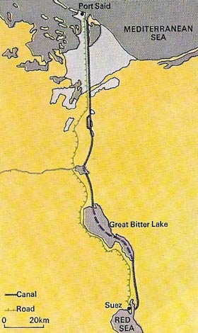 |
| The Suez Canal, opened after a decade of effort by French engineer Ferdinand de Lesseps (1805–1894) was dug out of the desert by hand. It connects the Red Sea with the Mediterranean and covers a distance of 169 kilometers (105 miles). It has a minimum width of 150 meters (500 feet) and a minimum depth of 10 meters (33 feet). Britain bought a controlling share in the canal from the Khedive of Egypt in 1875 and retained control until Egypt's President Nasser nationalized it in 1956. The canal was blocked with sunken ships during the 1967 Arab-Israeli war and was cleared and reopened in 1975. |
One of the earliest reports of a man-made canal tells of one completed by Ptolemy II (died 247 BC) of Egypt to link the River Nile with the Red Sea. Natural inland waterways such as major rivers had been used as trans-port routes since earliest times and primitive single-gate locks are known to have been used in China from about 500 BC. These were openings in weirs through which water poured. Boats were carried downstream by the rushing waters or winched up against the current. A two-gate lock, built at Vreeswijk, Holland, in 1373, is believed to have been the first true pound-lock – a lock in which the flow of water is controlled by alternately lifting up or lowering the gates. The first to have swinging mitre gates of the kind used today was designed and built by Leonardo da Vinci (1452–1519) when he was engineer to the Duke of Milan. Miter lock gates, when closed, form an angle pointing upstream so that water pressure holds them shut.
In 1681 French engineers made history when they completed the 250-kilometer (155-mile) long Canal du Midi linking the Atlantic Ocean with the Mediterranean Sea by a man-made waterway. It had many locks connecting the River Garonne, near Toulouse, with the River Etang de Thau, near Sete and included three aqueducts and a tunnel.
The greatest single obstacle to the industrial development of Europe and the United States in the 18th century was poor internal communication. Thus it was the needs of industry that brought about the dawn of the canal age on both sides of the Atlantic.
In the United States canals were built to link the Ohio and Mississippi basins (Fig 1) with the east coast ports, to provide routes from inland areas to the navigable rivers and to bypass natural obstacles on these rivers. The most spectacular early American achievement was the completion, in 1825, of the 580-kilometer (363-mile) Erie Canal linking New York City with Lake Erie. It took eight years to build. The lake was subsequently connected by canal to the Ohio River and so to the Mississippi and the port of New Orleans.
The British achievement
By 1850 England was traversed by more than 8,000 kilometers (5,000 miles) of navigable rivers and canals. Canals were also constructed throughout Europe, especially along the North Sea coasts of the Netherlands, Belgium and France.
During the nineteenth century British civil engineers conceived and constructed a perennial irrigation system in northwestern India (Figure 5) in which huge masonry barrages were built across the rivers to divert part of the water into a great network of canals. By the time India and Pakistan gained independence in 1947 the subcontinent had more than 20 million hectares (50 million acres) of previously arid land under irrigation.
Technique of canal engineering
A canal, unlike a road, must be built in level sections and the canal engineer's first problem is the selection of a route along which a level can be maintained with the minimum of engineering work. This problem is approached by siting a canal to run as far as possible along the natural land contours. Where high ground must be crossed the cut can be correspondingly deeper or the canal can be built in a tunnel. Where there is an unavoidable depression in the ground the best solution is to construct the canal along a low embankment. There comes a point where the rise or fall of the land to be traversed requires so deep a cut, so long a tunnel or so high an embankment or aqueduct that it is more economic to build a lock and continue the canal at a new level.
Wherever canals are built obstacles, such as roads, streams and rivers, have to be crossed. If they are roads or railways, bridges must be built; if they are waterways, then either the canal or the waterway must be carried on an aqueduct. Where locks are introduced there must be a sufficient supply of water at the highest level to replace the water that flows when any lock is used (Figure 4).
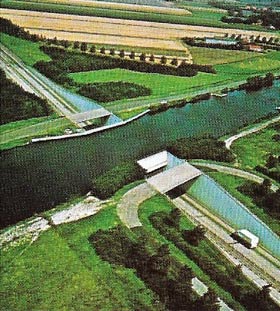 |
| An aqueduct built over a road is often necessary in canal engineering for economic reasons, as in this case in the Netherlands. Because the canal is full of water it has to be built to one level throughout, or in level reaches connected by locks. This is achieved by judicious choice of route, by cutting deeper into high ground, and by building on a raised embankment over low-lying areas. Most roads cross canals by bridges. |
A canal must not lose excessive water by seepage into the ground. Where the ground is porous, and where a canal runs along a man-made embankment, the engineer must waterproof its bottom and sides. In early canals this was achieved by lining the canal with puddled clay. Today there are alternative materials including bituminous materials, sheet polythene and concrete. Machines have been developed to lay a continuous concrete lining at minimum cost and these are increasingly used for irrigation canals in the Middle East and other arid areas to carry water long distances.
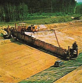 |
| Construction techniques in canal engineering include the use of special lining machines, as in the Jordan Canal section of Israel's National Water Carrier. Wet concrete is fed on to a conveyor belt and as the machine moves forward on caterpillar tracks, an even layer 10 centimeters (4 inches) thick is laid as a continuous strip. The Israeli system carries water 28 kilometers (17 miles) from Lake Tiberius southward in an open canal to feed a pipeline extending much farther to the south. |

