
glacier
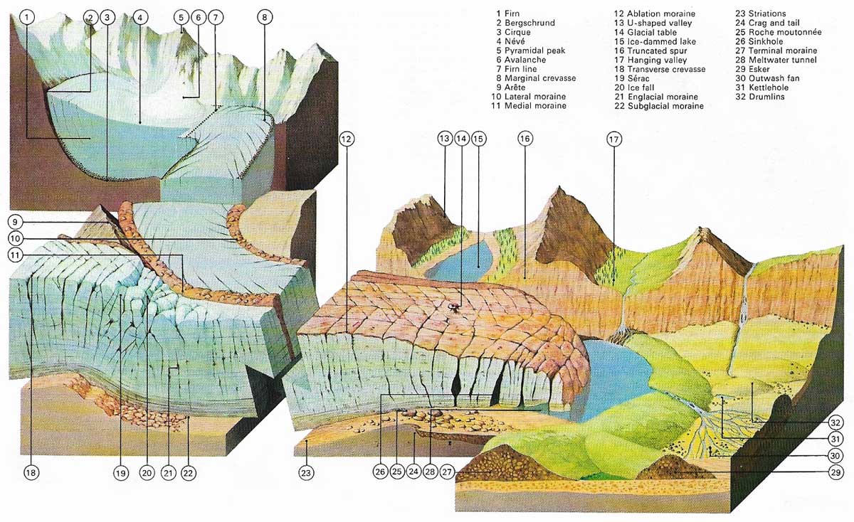
Figure 1. Birthplace of the valley glacier is the cirque where perennial snow gathers as névé and is compressed to firn. Pulling away from the valley head, the glacier forms a crevasse, the bergschrund. The ice flows fastest at the surface along the glacier's axis. This, with irregularities of the glacial bed, creates crevasses; where these intersect séracs are formed. Glaciers carve the mountains into ridges (arêtes), peaks or horns, and valleys into steep-sided troughs. U-shaped valleys, where glaciers once flowed, have floors that are deeper than those of tributary valleys, leaving the latter "hanginging" and often draining by a waterfall. The load of moraine (rock debris) carried away by the glacier deposited at its snout is called till. The glacier melts on the surface along its lower section. The amount of melting can be judged from the height of the glacier tables – unmelted ice pinancles shaped by a moraine boulder. Meltwaters for subglacial streams which deposit long, winding piles of rubble called eskers under the snout. Other material under the ice forms drumlins and terminal moraines are deposited by retreating glaciers while stationary.
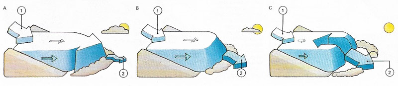
Figure 2. The material in a glacier moves constantly downhill. The position of the glacial snout, however, may move downhill (A), remain stationary (B) or move uphill (C) depending on the rate of melting of the ice (2) compared with the rate at which it accretes (1).
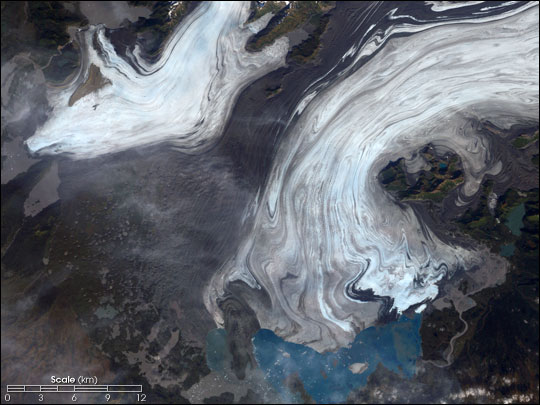
Figure 3. Bering Glacier, Alaska. Credit: NASA.
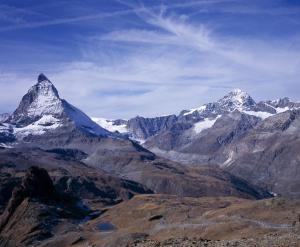
Figure 4. The Matterhorn.
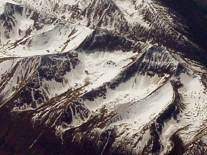
Figure 5. Southwest-looking oblique aerial photograph showing a number of snow-covered cirques, cut into the summit of a Coast Mountains ridge along the Alaska-Canada border, east of Glacier Bay National Park, Alaska. Credit: USGS.
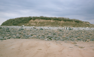
Figure 6. The flank of a drumlin composed of glacial till. The length of this drumlin is about 1/8 mile. Note the two people for scale. Cranes Beach, MA. Credit: USGS.
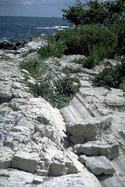
Figure 7. Glacial grooves, East Sister Island, Lake Erie, Ontario, Canada. The glacial grooves shown here are roughly 385 million years old, and were created from the gouging action of ice flowing in the Lake Erie basin. Source: Natural Resources Canada / R. N. McNeely.
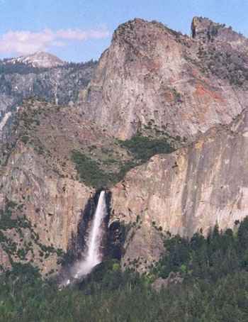
Figure 8. Bridal Veil Falls, Yosemite, and a hanging valley.
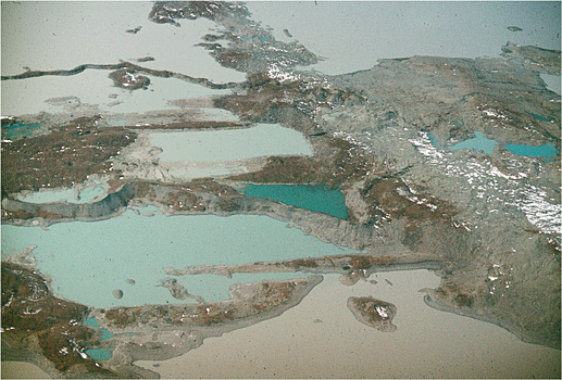
Figure 9. North-looking oblique aerial photograph of a complex sediment mass deposited by the retreating Malaspina Glacier in Malaspina Lake. Included are meandering eskers, linear crevasse fills and a massive ice cored kame. Wrangell-Saint Elias National Park, Chugach Mountains, Alaska. Photo credit: USGS.
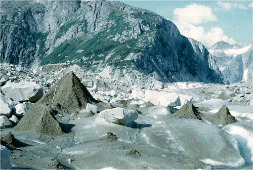
Figure 10. August 1968 southwest-looking photograph of the surface of the Bucher Glacier, an outlet glacier of the Juneau Icefield, showing several glacier tables, several conical mounds of sediment-covered ice, and several small piles of sediment left on the ice surface marking the position of former mounds, Coast Mountains, Tongass National Forest, Alaska. Credit: USGS.
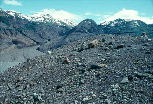
Figure 11. The surface of the ground in this area adjacent to Sherman glacier is covered with a coarse glacial till. Chugach Mountains, Chugach National Forest, Alaska. Credit: USGS.
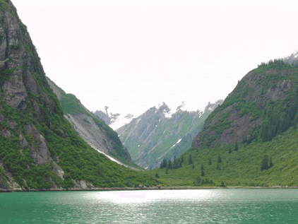
Figure 12. Northeast-looking photograph of a symmetrical, unnamed U-shaped valley cut into the crystalline rocks of the Coast Mountains, Tracy Arn, Tracy Arm-Ford's Terror Wilderness, Tongass National Forest, Arkansas. The valley walls are more than 2,000 feet high and the valley is about 1/4 mile wide.
A glacier is a large mass of ice that can survive for many years. In most cases, glaciers are heavy enough to flow downhill under their own weight. They are significant agents of erosion. Three main types of glacier are recognized: ice sheets and caps, which spread over their source area; mountain or valley glaciers, which have their sources in the mountains above the snow line; and piedmont glaciers, formed by the joining of valley glaciers as they spread out at the foot of mountains. Many existing landforms were created by the action of ice (which both destroys old features and creates new ones) during the ice of the Pleistocene, when as much as 30 percent of the land surface was glaciated.
Glaciers form wherever conditions are such that annual precipitation of snow, sleet, and hail is greater than the amount that can be lost through evaporation or otherwise. The occurrence of a glacier thus depends on the latitude and also on local topography: there are several glaciers on the equator.
Glaciers account for about 75 percent of the world's fresh water, and of this the Antarctic ice sheet accounts for about 85 percent.
Mountain glaciers usually result from snow accumulated in cirques coalescing to form glaciers; and piedmont glaciers occur when such a glacier spreads out of its valley into a contiguous lowland area.
Erosion and transport
A glacier is one of the most powerful agents of erosion. Its ice erodes by abrasion and by plucking away at the bedrock. Blocks embedded in the ice are scraped along the bottom, produced striated (grooved)rocks, and resistant rocks are polished into roches moutonnées. The source area is enlarged into an amphitheater known as a cirque or corrie, and where two such cirques meet they are separated by a sharp ridge called an arête. Three cirques overlapping produce at their center a pyramidal peak or horn, of which a classic example is the Matterhorn on the Swiss-Italian border. Mountain glaciers carve their valleys into deep U-shaped troughs;bigger glaciers have deeper valleys than their smaller affluents, giving rise to hanging valleys after the glaciers have disappeared.
Glacier carry huge loads of debris or moraine. Rocks falling from above on to the sides of a glacier form lateral moraines ad where two glaciers converge the inner lateral moraines merge to form a medial moraine. Some debris falls into crevasses to form an englacial moraine and can work its way down to the rocks plucked off the bed and become part of the subglacial moraine.
Glacial deposits
The glacier's debris is eventually deposited at its foot, forming the terminal moraine which is made of totally ungraded material ranging from clay to huge boulders. If the glacier retreats, the abandoned frontal moraine often makes a dam retaining a lake and other lakes appear in the hard-rock depressions carved by the glacier. Rapidly retreating glaciers dump their loads as they go, leaving large rocks as clues to their former size; they also give characteristics and valuable information about former ice ages.
Movement of mountain glaciers
In 1788 the Swiss physicist Horace de Saussure (1740–1799) lost an iron ladder on an Alpine glacier. It was found, 44 years later, 4,350 meters (14,250 feet) lower down, thus demonstrating glacial movement.
Ice is a crystalline solid, but it can deform and flow when subjected to a sustained pressure. In glaciers this occurs by slippage of the ice crystals, which are lubricated along their boundaries by a thin layer of liquid water melted by the pressure. The downward motion (Figure 3) of the glacier can be seen at its very top where it is separated from the permanent snow by a deep crevasse known as the bergschrund. Lower down, the movement can be observed by taking sights from fixed points on the mountainside along rows of stakes planted across the glacier. These also show the differential movement of the ice, for a glacier moves faster in its center than it does along its edges, where it is slowed by friction. Along a vertical section the speed is fastest on the surface slab, which behaves in a rigid fashion (it breaks, forming crevasses), and the speed decreases toward the bottom. Longitudinal crevasses appear in the surface slab owing to the increasing rate of flow toward the axis of the glacier tongue or owing to the widening of the glacier; transverse crevasses are formed where the slope suddenly increases. Where transverse and longitudinal crevasses intersect, a spectacular ice topography of blocks or pinnacles of ice known as séracs is created.
The rate of movement of a glacier varies considerably and is dependent on the slope, thickness, cross-sectional area, roughness of the bottom, and the temperature. Rates can vary from a few centimeters a day to several hundred – 66 meters (216 feet) in the case of an Alaskan glacier.
A glacier can be divided into an upper section, where the temperature, prevents melting and more ice is formed, and a lower section where the temperature is higher and ice is lost through melting. A steady rate is achieved when the accretion of ice in the upper section roughly balances that lost lower down. In these conditions the foot of the glacier is stationary. If the climate becomes cooler, the foot of the glacier advances until a new state of equilibrium is reached; under warmer conditions the foot of the glacier retreats to an equilibrium.
Features associated with glaciers
arète
An arète is a sharp ridge formed by erosion where the heads of two glaciers meet. A well-known example is the Matterhorn on the Swiss-Italian border (Figure 4).
bergschrund
A bergschrund is a deep, wide crevasse or a series of parallel narrow crevasses in a glacier, produced by tension within the ice, often at the point where the moving ice pulls away from the rock slope at the head of the glacier cirque.
cirque
A cirque, also known as a corrie (in Scotland) or cwm (in Wales), is a bowl-shaped, steep-sided hollow formed by glacial erosion, usually occupied by a lake where the glacier has retreated, or by névé where the glacier is still present (Fig 5). Typically, a cirque has a lip at its lower end. The term is French and is derived from the Latin word circus. See also erosion.
col
A col is a low smooth depression in a mountain range, often forming a pass through it. It is generally caused by the action of two opposing glaciers, the heads of which are commonly separated by an arête a sharp-crested ridge between the two cirques (valleys) formed by the glaciers.
crevasse
A crevasse is a deep crack in a glacier. It is the result of stress within the glacier or the movement of the glacier over uneven terrain.
drift
Sedimentary drift is a general description of surface debris carried either by a river or glacier.
drumlin
A drumlin is an elongated hillock, formed of till, found usually in swarms in lowland areas formerly occupied by a glacier (Fig 6). Drumlins usually taper away from a steep slope that faced the incoming ice.
glacial drift
Glacial drift is sediment and rocks transported by glaciers and deposited directly on the land or indirectly in streams, lakes, and oceans. It consists of a heterogeneous mixture of clay, silt, sand, gravel, and boulders ranging in size and shape.
glacial groove
A glacial groove is a deep, wide, usually straight furrow cut in bedrock (Figure 7). It is caused by the abrasive action of large rock fragments dragged along the base of a moving glacier. The grooves are larger and deeper than glacial striations, ranging in size from a deep scratch to a glacial valley.
hanging valley
A hanging valley is a tributary valley that ends high up the face of a larger main valley, possibly with a stream running through it and ending in a waterfall (Fig 8). Hanging valleys are usually associated with U-shaped valleys, and result from a tributary glacier having flowed into a glacier of larger volume. The main glacier eroded a deep U-shaped valley with nearly vertical sides while the tributary glacier, with a smaller volume of ice, made a shallower U-shaped valley. Since the surfaces of the glaciers were originally at the same elevation, the shallower valley appears to be hanging above the main valley.
A well known example is the hanging valley in Yosemite National Park over which Bridal Veil Falls plummets.
kame
Kame is a deposit formed by a subglacial stream near the terminal margin of a melting glacier (Figure 9). Streams flowing down mountain sides onto glaciers deposit sand and gravel at the point where the stream first reaches the ice, or where the water goes down into a crevasse. The accumulation of sand and gravel gradually fall down to the valley floor as the ice melts.Kames are generally small features, 20–30 meters (65–100 feet) in length or breadth. Shapes include hills, mounds, knobs, hummocks, or ridges.
moraine
Moraine is an accumulation of boulders and rock fragments carried or deposited by a glacier (Figure 10). Ground moraine is drift left in a sheet as a glacier retreats. Terminal moraine are ridges deposited when the ice is melting prior to the glacial retreat; a series of ridges may mark pauses in the retreat. Lateral moraines are formed of debris that falls onto the glacier: when two glaciers merge their lateral moraines may unite to form a medial moraine.
till
Till, also known as boulder clay, is the unsorted material left behind on the land after the retreat of a glacier (Figure 11). Till is a heterogeneous mixture of different sized material deposited by moving ice (lodgement till) or by the melting in-place of stagnant ice (ablation till). After deposition, some tills are reworked by water.
U-shaped valley
A U-shaped valley is a valley with a parabolic or 'U' shaped cross-section, steep walls, and generally a broad and flat floor (Figure 12). Formed by glacier erosion, a U-shaped valley results when a glacier widens and over-steepens a V-shaped stream valley.

