
Roman rule in Britain
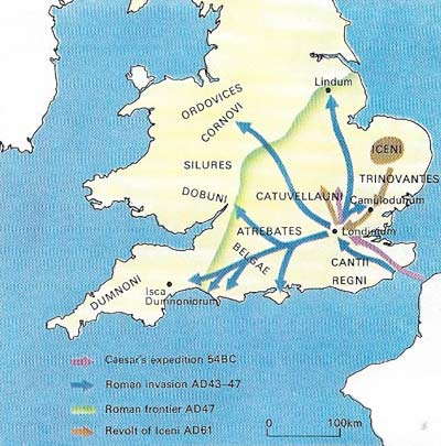
Figure 1. The two Roman invasions came about for different reasons. Julius Caesar saw the British campaign as a diversion from his main task of subduing Gaul, and retired after achieving his aim of defeating the British chief Cassivellaunus. By comparison Claudius hoped to confirm his own dubious power in Rome and at the same time saw the creation of a new colony in Britain as a means to balance the great power of the generals on the Rhine. Southeast Britain was the center of both Celtic and Roman Britain at this time; the Fosse Way was the frontier of Roman Britain in AD 47, and served as a springboard for advances into south Wales in AD 49 and north Wales in AD 61.
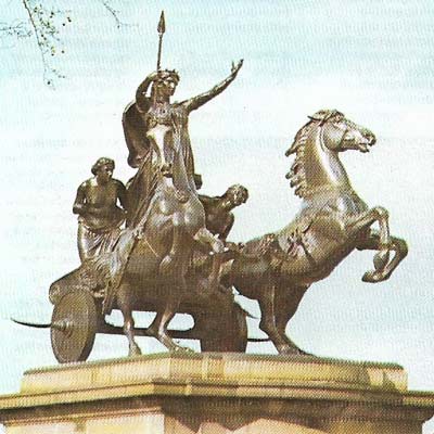
Figure 2. Boadicea, warrior queen of the Iceni in East Anglia, riding in her war chariot, symbolizes revolt against Roman oppression. This massive sculpture, executed by Thomas Thornycroft in 1902, stands nationalistically at the west end of Westminster Bridge, London.
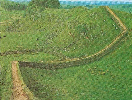
Figure 3. A long stretch of Hadrian's Wall that is better preserved than most runs along the Whin Sill escarpment near the large fort of Housesteads. The wall runs for 117.5 kilometers (73.5 miles – 80 Roman miles) from Wallsend-on-Tyne to Bowness-on-Solway. It was built in the AD 120s, after a visit by the Emperor Hadrian, to help to defend the empire's most northerly frontier from invasions by the Picts. It was several times overrun and rebuilt, before the border was finally abandoned to the Picts in AD 383.
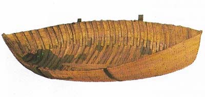
Figure 4. This reconstructed Roman boat is typical of the craft used by the Romans to bring troops and supplies from Gaul and up the main rivers of southern Britain. But communication by road was soon developed as the most efficient means of military control.
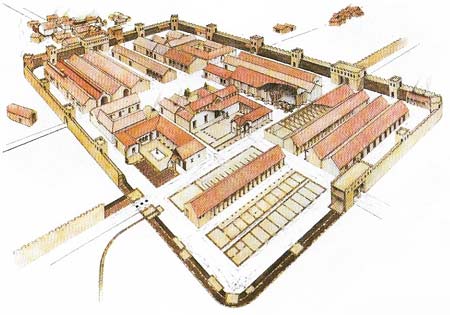
Figure 5. The typical Roman fort would hold 500 to 1,000 men. Each fort was strengthened by a wall with an earth rampart banked against it. From the main gate (porta praetorian) a main street (via praetorian) led to the headquarters building (principia). From there the other main street led to the side gateways, the porta principalis dextra and portaprincipalis sinistra. Within the fort there would usually be barracks for the troops and their officers, a workshop, granaries, stables, armories, the regimental chapel, and the commandant's house. Water would be supplied by an aqueduct running from a nearby river. Civilian settlements were often built and grew up outside the walls of the fort to provide a measure of comfort. Forts were built along Hadrian's Wall at regular intervals in order to repel aggressive barbarian tribesmen.
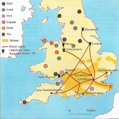
Figure 6. The map of Roman Britain during the early decades of conquest and control shows roads, towns, frontiers, fort systems, and industrial and agricultural regions. Throughout their empire, the Romans put the emphasis on urban rather than on rural life. The first of many towns they founded in Britain was at Colchester, while other towns developed from the settlements outside the military stations. The largest element of local government was the civitas (community), which was based on already existing tribal groupings. The most important towns received the title of colonia or municipium. Such towns were permitted to elect a town senate, which provided magistrates for administrative duties.
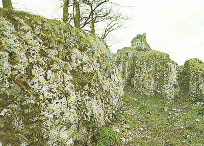
Figure 7. The Roman fort of Anderida at Pevensey in Sussex was built c. AD 280 to defend the south coast against Germanic invaders. A chain of these forts was built from Norfolk to the Isle of Wight to protect important harbors against the incursions of Saxon sea raiders. Others were built on the west coast. In AD 491 the Saxons stormed Anderida and slaughtered everyone in it. Today the fort stands several miles away from the shore because of the silting of the harbors.
The Romans ruled Britain, or at least its southern half, for more than 300 years. The northern frontier was always a problem, but much of England enjoyed a peaceful and prosperous existence as one of the provinces of the Roman Empire. The people, particularly in the towns, adopted many of the social and religious practices of their occupiers. The final collapse of Roman power resulted as much from civil strife in Italy as from unrest among the Britons.
Patterns of conquest
A century separated the Romans' first tentative probes into Britain and their full-scale expedition of conquest. Britain fascinated the Romans as a strange romantic land in much the same way as the New World fascinated the Elizabethans. But the Romans also coveted its mineral wealth and realized its important strategic position. Julius Caesar (c. 100–44BC) was anxious to cut off the aid that the Britons were giving to the Gauls. His first landing, in 55 BC, achieved little of substance. In his second attempt the following year he marched north and probably captured the defenders' stronghold at Wheathampstead, Hertfordshire.
The Emperor Claudius, anxious to give some shine to his exceptionally dull image, ordered the conquest of Britain in AD 43. The troops of four legions (3,000 to 6,000 men in each), plus auxiliary regiments of provincials, landed and made their main base at Richborough. The invaders soon won a major victory on the River Medway. The main British force under Caractacus (died AD 54) withdrew and avoided further pitched battles. Claudius himself made a brief visit to lead his forces triumphantly into Colchester (Camulodunum).
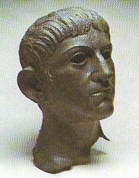 |
| A bronze head of Claudius, Emperor of Rome from AD 41 to 54, was found in the River Alde in Suffolk. Claudius instigated and took a close personal interest in the conquest of Britain, which was important for his own prestige. During the 16 days that he spent campaigning in Britain he led his troops from the Thames and quickly captured Colchester. He also received the surrender of many tribes. |
The south and Midlands up to the Trent and Severn rivers were occupied without much opposition being met. But in Wales Caractacus led a stubborn resistance based on guerrilla tactics. When he was eventually inveigled into the open he was defeated, and was taken prisoner to Rome and exhibited in the triumph awarded to the successful Roman general. By AD 61 the Romans controlled England as far north as the River Humber. But in that year Boadicea (Boudicca) (Figure 2), Queen of the Iceni in East Anglia, led a revolt which spread so quickly that the governor, Suetonius Paulinus, was forced to abandon Colchester, London (Londinium) and St Albans (Verulamium). Inevitably the greater armed power, skill and discipline of the Romans prevailed and the rebellion was crushed with savage reprisals.
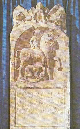 |
| The arrogant attitude of the Romans towards the conquered Britons in the early years of their occupation is graphically illustrated by this scene of a Roman cavalryman trampling a Briton under his horse's hoofs. The horseman, named Longinus, came from Sofia, in modern Bulgaria, and was a duplicarius (junior officer) in a Thracian cavalry detachment. The scene was carved on a tombstone found on the site of Colchester. The troops of Boadicea (died AD 62) defaced the tomb, overthrew the headstone, and burnt Colchester as an act of vengeance after the Romans had violently taken over the territory of the lceni, flogged Boadicea and raped her daughters. |
Consolidation and administration
By AD 80 the whole of Wales had been subdued. The new governor, Agricola (AD 37–93), pushed the frontier northwards to the Forth and Clyde, and at the Battle of Mons Graupius gained the whole of lowland Scotland. But as elsewhere in their empire, the Romans found it difficult to maintain their expanding frontiers securely. A period of consolidation led to the building of Hadrian's Wall (Figure 3) between the Tyne and the Solway during the AD 120s. Under the Emperor Antoninus Pius further attempts were made to subdue Scotland, and the Antonine Wall was built linking the Firth of Forth and the Firth of Clyde. Hadrian's Wall fell into disuse for a period but by about AD 200 it again formed the northern frontier.
The first capital of the province of Britannia was Colchester, but London soon succeeded it as the center of administration and trade. The bridge over the Thames there was the focal point of the road network and of the sea trade routes. London was burnt during Boadicea's rebellion but was quickly rebuilt and became one of the largest cities in the Roman Empire. The governor was assisted by an iuridicus who was responsible for justice in the civilian zone, and by many civil servants. Taxation and the treasury were under an independent procurator.
In the early third century Britain was divided into two provinces. London was the capital of Britannia Superior and York (Eburacum) became the capital of Britannia Inferior. Later, four provinces and then five were created. Communities had considerable control over their own affairs and the coloniae (important towns) (Fig 6) of Colchester, Lincoln (Lindum) and Gloucester (Glevum) were virtually self-governing.
Most Britons lived a settled, peaceful life under civil rule. But the territories between the Humber and Hadrian's Wall, much of Wales and some other areas, were under military rule and were controlled through a network of large garrison bases and smaller fortresses. The movement of troops was aided by an excellent road system. Roads and forts (6) always followed close on conquests. Important roads were Watling Street, from Dover (Dubrae) to Chester (Deva), Ermine Street, from London to York, and the Fosse Way, from Lincoln to near Axminster.
Withdrawal and abandonment
In the fourth century Saxon raiders became a serious threat to the southeast coast while the Picts and Scots increased pressure on the northern frontier, destroying Hadrian's Wall and overrunning much of the north in AD 367. The situation was temporarily restored but Roman forces began to withdraw, and by the early fifth century had completely abandoned the island. The last appeal for help was rejected by the authorities in Rome in AD 446 and the Anglo-Saxons began the process of effacing or transforming many of the signs of Roman occupation.