
EGNOS (European Geostationary Navigation Overlay Service)
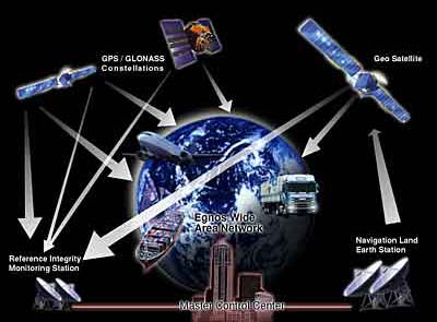
EGNOS (European Geostationary Navigation Overlay Service) is a European satellite navigation system intended to augment the two operational military satellite navigation systems – the American GPS and the Russian GLONASS – and make them suitable for safety-critical applications such as flying aircraft or navigating ships through narrow channels. Consisting of three geostationary satellites and a network of ground stations, EGNOS will transmit a signal containing information on the reliability and accuracy of the positioning signals sent out by GPS and GLONASS. It will allow users in Europe and beyond to determine their position to within 5 m, compared with about 20 m at present. EGNOS is a joint venture of ESA (European Space Agency), the European Commission, and the European Organisation for the Safety of Air Navigation. It is Europe's contribution to the first stage of a global navigation system, GNSS, and is a precursor to the Galileo satellite navigation system.
It was announced on 28 July 2005, that the transfer of EGNOS operations from ESA to the operating company, European Satellite Services Provider, had begun. Prior to the system becoming fully operational, users could acquaint themselves with the facility using a test signal broadcast by two Inmarsat satellites.

