
Explorer
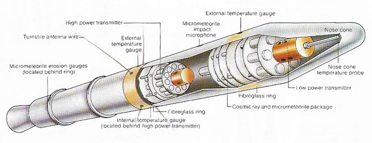
Explorer 1 cutaway.
Explorer is a long and ongoing series of small American scientific spacecraft. Explorer 1, the first successful American satellite, discovered the Van Allen belts. Explorer 6 took the first photo of Earth from space. Subprograms of the Explorer series have included ADE (Air Density Explorer), AE (Atmosphere Explorer), DME (Direct Measurement Explorer), EPE (Energetic Particles Explorer), GEOS (Geodetic Earth Orbiting Satellite), IE (Ionosphere Explorer), and IMP (Interplanetary Monitoring Platform). Among the more recent Explorers are IUE (International Ultraviolet Explorer) and COBE (Cosmic Background Explorer). Subcategories of the modern Explorer program include SMEX (Small Explorer), MIDEX (Medium-class Explorer), UNEX (University-class Explorer), and Missions of Opportunity, while the themes of the program are the Astronomical Search for Origins and Planetary Systems, the Sun-Earth Connection, and the Structure and Evolution of the Universe.
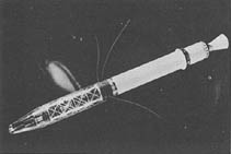 |
| Explorer 1.
|
The name "Explorer," designating NASA's scientific satellite series, originated before NASA was formed. "Explorer" was used in the 1930s for the US Army Air Service-National Geographic stratosphere balloons. On 31 January 1958, when the first US satellite was orbited by the US Army as a contribution to the International Geophysical Year (IGY), Secretary of the Army Wilbur M. Brucker announced the satellite's name, Explorer 1. The name indicated the mission of this first satellite and its NASA successor – to explore the unknown.
| Explorer | launch date | launch vehicle | launch site | orbit | mass (kg) |
| 1 | Feb 1, 1958 | Juno 1 | Cape Canaveral | 358 × 2,550 × 33° | 5 |
| 2 | Mar 5, 1958 | Juno 1 | Cape Canaveral | failed to reach orbit | 5 |
| 3 | Mar 26, 1958 | Juno 1 | Cape Canaveral | 186 × 2,799 × 33° | 5 |
| 4 | Jul 26, 1958 | Jupiter | Cape Canaveral | 263 × 2,213 × 50° | 8 |
| 5 | Aug 24, 1958 | Juno 1 | Cape Canaveral | failed to reach orbit | 17 |
| 6 | Aug 7, 1959 | Thor-Able | Cape Canaveral | 237 × 41,900 × 47° | 64 |
| 7 | Oct 13, 1959 | Juno 2 | Cape Canaveral | 573 × 1,073 × 50° | 42 |
| 8 | Nov 3, 1960 | Juno 2 | Cape Canaveral | 417 × 2,288 × 50° | 41 |
| 9 | Feb 16, 1961 | Scout X-1 | Wallops Island | 545 × 2,225 × 39° | 7 |
| 10 | Mar 25, 1961 | Delta | Cape Canaveral | highly elliptical | 35 |
| 11/Met. Sat 1 | Apr 27, 1961 | Juno 2 | Cape Canaveral | 486 × 1,786 × 29° | 37 |
| 12/EPE-1 | Aug 16, 1961 | Delta | Cape Canaveral | 790 × 76,620 × 33° | 38 |
| 13/Met. Sat 2 | Aug 25, 1961 | Scout X-1 | Wallops Island | wrong orbit | 86 |
| 14/EPE-2 | Oct 2, 1962 | Delta A | Cape Canaveral | 2,601 × 96,189 × 43° | 40 |
| 15/EPE-3 | Oct 27, 1962 | Delta A | Cape Canaveral | 300 × 17,438 × 18° | 44 |
| 16/Met. Sat 3 | Dec 16, 1962 | Scout X-3 | Wallops Island | 744 × 1,159 × 52° | 100 |
| 17/AE 1 | Apr 5, 1963 | Delta B | Cape Canaveral | 254 × 891 × 57° | 185 |
| 18/IMP-1 | Nov 26, 1963 | Delta C | Cape Canaveral | 192 × 197,616 × 33° | 62 |
| 19/ADE 1 | Dec 19, 1963 | Scout X-4 | Vandenberg | 597 × 2,391 × 79° | 7 |
| 20/IE | Aug 25, 1964 | Delta C | Cape Canaveral | 855 × 1,001 × 80° | 44 |
| 21/IMP-2 | Oct 4, 1964 | Delta C | Cape Canaveral | 191 × 95,590 × 34° | 62 |
| 22/BE 2 | Oct 9, 1964 | Scout X-4 | Vandenberg | 872 × 1,053 × 80° | 52 |
| 23/Met. Sat. 4 | Nov 6, 1964 | Scout X-4 | Wallops Island | 463 × 980 × 52° | 134 |
| 24/ADE 2 | Nov 21, 1964 | Scout X-4 | Wallops Island | 530 × 2,498 × 81° | 9 |
| 25/Injun 4 | " | " | " | 524 × 2,349 × 81° | 40 |
| 26/EPE-4 | Dec 21, 1964 | Delta C | Cape Canaveral | 284 × 10,043 × 20° | 46 |
| 27/BE 3 | Apr 29, 1965 | Scout X-4 | Wallops Island | 932 × 1,309 × 41° | 60 |
| 28/IMP-3 | May 29, 1965 | Delta C | Cape Canaveral | 229 × 261,206 × 31° | 58 |
| 29/GEOS 1 | Nov 6, 1965 | Delta E | Cape Canaveral | 1,114 × 2,273 × 59° | 175 |
| 30/Solrad 8 | Nov 19, 1965 | Scout X-4 | Wallops Island | 667 × 871 × 60° | 57 |
| 31/DME | Nov 29, 1965 | Thor Agena A | Vandenberg | 502 × 2,857 × 80° | 99 |
| 32/AE 2 | May 25, 1966 | Delta C | Cape Canaveral | 282 × 2,723 × 65° | 225 |
| 33/IMP-4 | Jul 1, 1966 | Delta E | Cape Canaveral | 85,228 × 481,417 × 41° | 93 |
| 34/IMP-6 | May 24, 1967 | Delta E | Vandenberg | 242 × 214,379 × 67° | 75 |
| 35 IMP-5 | Jul 19, 1967 | Delta E | Cape Canaveral | n/a | 104 |
| 36/GEOS 2 | Jan 11, 1968 | Delta E | Vandenberg | 1,079 × 1,572 × 106° | 209 |
| 37/Solrad 9 | Mar 5, 1968 | Scout B | Wallops Island | 353 × 433 × 59° | 198 |
| 38/RAE 1 | Jul 4, 1968 | Delta J | Vandenberg | 5,835 × 5,861 × 121° | 190 |
| 39/ADE 3 | Aug 8, 1968 | Scout B | Vandenberg | 670 × 2,583 × 81° | 9 |
| 40/Injun 5 | " | Scout B | Vandenberg | 677 × 2,494 × 81° | 70 |
| 41/IMP-7 | Jun 21, 1969 | Delta E | Vandenberg | 80,374 × 98,159 × 86° | 174 |
| 42/SAS 1 | Dec 12, 1970 | Scout B | San Marco | 521 × 570 × 3° | 143 |
| 43/IMP-8 | Mar 13, 1971 | Delta M | Cape Canaveral | 1,845 × 203,130 × 31° | 288 |
| 44 Solrad 10 | Jul 8, 1971 | Scout B | Wallops Island | 433 × 632 × 51° | 118 |
| 45/SSS-1 | Nov 15, 1971 | Scout B | San Marco | 272 × 18,149 × 3° | 52 |
| 46/MTS | Aug 13, 1972 | Scout D | Wallops Island | 492 × 811 × 38° | 136 |
| 47/IMP-9 | Sep 22, 1972 | Delta 1914 | Cape Canaveral | 201,100 × 235,600 × 17° | 376 |
| 48/SAS 2 | Nov 16, 1972 | Scout D | San Marco | 526 × 526 × 1° | 185 |
| 49/RAE 2 | Jun 10, 1973 | Delta 1914 | Cape Canaveral | 1,053 × 1,064 × 56° | 328 |
| 50/IMP-11 | Oct 25, 1973 | Delta 1914 | Cape Canaveral | 141,185 × 288,857 × 28° | 371 |
| 51/AE 3 | Dec 16, 1973 | Delta 1914 | Vandenberg | 155 × 4,306 × 68° | 658 |
| 52/Hawkeye | Jun 3, 1974 | Scout D | Vandenberg | 469 × 125,569 × 89° | 27 |
| 53/SAS 3 | May 7, 1975 | Scout F | San Marco | 498 × 507 × 3° | 195 |
| 54/AE 4 | Oct 6, 1975 | Delta 2914 | Vandenberg | 151 × 3,819 × 90° | 676 |
| 55/AE 5 | Nov 20, 1975 | Delta 2914 | Cape Canaveral | 154 × 3,002 × 20° | 721 |
| 56/ISEE-1 | Oct 22, 1977 | Delta 2914 | Cape Canaveral | 436 × 137,806 × 13° | 340 |
| 57/IUE | Jan 26, 1978 | Delta 2914 | Cape Canaveral | 30,285 × 41,296 × 34° | 672 |
| 58/HCMM | Apr 26, 1978 | Scout D | Vandenberg | 560 × 641 × 98° | 134 |
| 59/ISEE-3 | Aug 12, 1978 | Delta 2914 | Cape Canaveral | 181 × 1,089,200 × 1° | 479 |
| 60/SAGE | Feb 18, 1979 | Scout D | Wallops Island | 456 × 506 × 55° | 147 |
| 61 Magsat | Oct 30, 1979 | Scout G | Vandenberg | 352 × 561 × 97° | 181 |
| 62 DE-1 | Aug 3, 1981 | Delta 3914 | Vandenberg | 568 × 23,289 × 90° | 424 |
| 63 DE-2 | " | " | " | 309 × 1,012 × 80° | 420 |
| 64 SME | Oct 6, 1981 | Delta 2914 | Cape Canaveral | 335 × 337 × 98° | 437 |
| 65 AMPTE/CCE | Aug 16, 1984 | Delta 3925 | Cape Canaveral | 1,121 × 49,671 × 5° | 242 |
| 66 COBE | Nov 18, 1989 | Delta 5920 | Vandenberg | 872 × 886 × 99° | 2,265 |
| 67 EUVE | Jun 7, 1992 | Delta 6925 | Cape Canaveral | 510 × 524 × 28° | 3,275 |
| 68 SAMPEX | Jul 3, 1992 | Scout G | Vandenberg | 506 × 670 × 82° | 158 |
| 69 RXTE | Dec 30, 1995 | Delta 7920 | Cape Canaveral | 409 × 409 × 29° | 3,200 |
| 70 FAST | Aug 21, 1996 | Pegasus XL | Vandenberg | 353 × 4,163 × 83° | 187 |
| 71 ACE | Aug 25, 1997 | Delta 7920 | Cape Canaveral | halo | 785 |
| 72 SNOE | Feb 26, 1998 | Pegasus XL | Vandenberg | 529 × 581 × 98° | 120 |
| 73 TRACE | Apr 2, 1998 | Pegasus XL | Vandenberg | 602 × 652 × 98° | 250 |
| 74 SWAS | Dec 6, 1998 | Pegasus XL | Vandenberg | 637 × 651 × 70° | 288 |
| 75 WIRE | Mar 5, 1999 | Pegasus XL | Vandenberg | 540 × 590 × 98° | 259 |
| 76 TERRIERS | May 18, 1999 | Pegasus XL | Vandenberg | 537 × 552 × 98° | 120 |
| 77 FUSE | Jun 24, 1999 | Delta 7925 | Cape Canaveral | 753 × 769 × 25° | 1,400 |
| 78 IMAGE | Mar 25, 2000 | Delta 7326 | Vandenberg | 1,000 × 45,922 × 40° | 494 |
| 79/HETE-2 | Oct 9, 2000 | Pegasus | Kwajalein | 598 × 641 × 1.9° | 124 |
| 80/MAP | Jun 30, 2001 | Delta 7425 | Cape Canaveral | 1,000 × 45,922 × 40° | 840 |
| 81/RHESSI | Feb 5, 2002 | Pegasus | Cape Canaveral | 1,000 × 45,922 × 40° | 293 |

