
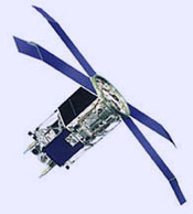
OrbView
OrbView satellites are designed to provide high-resolution images of Earth from orbit,
which ORBIMAGE (Orbiting Image Corporation), a company half-owned by Orbital
Sciences, sells to civilian, government, and military customers. OrbView-1,
launched in 1995 and originally called MicroLab,
provides atmospheric imagery; OrbView-2, launched in 1997 and originally
called Seastar, supplies images of both
ocean and land. OrbView-4 carried a camera able to snap 1-meter resolution black
and white and 4-meter resolution color images from a 470-kilometer orbit. It also carried
a hyperspectral imaging instrument for the Air Force Research Laboratory's
Warfighter-1 program, which would have made it the first commercial satellite
to produce hyperspectral imagery. The United States military is interested
in this technique because it has promising uses for detecting chemical or
biological weapons, collecting bomb damage assessment for commanders, and
finding soldiers and enemy vehicles hidden under foliage. However, OrbView-4
was lost minutes after a faulty launch by its Taurus booster on 21 September 2001. (Also destroyed on the same flight was NASA's QuikTOMS.) OrbView-3 which carries the
same camera as its ill-fated sibling, but not the hyperspectral imager,
was launched aboard a Pegasus XL from Vandenberg Air Force Base on 26 June 2003. It moves in a circular orbit with an altitude of 470 kilometers and an
inclination of 97°.
 |
| OrbView-2
|

