
Seasat
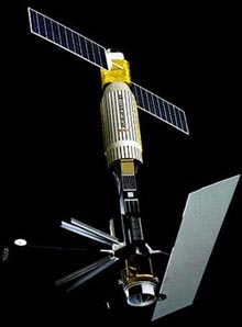
Seasat was a a NASA/JPL (Jet Propulsion Laboratory) satellite that carried out the first remote sensing of Earth's oceans using synthetic aperture radar (SAR). The mission ended on 10 October 1978, due to a failure of the vehicle's electric power system. Although only about 42 hours of real-time data was received, the mission proved the feasibility of using microwave sensors to monitor ocean conditions, and laid the groundwork for future SAR missions. As well as the SAR, Seasat's payload included a scatterometer to measure wind speed and direction, a multichannel microwave radiometer to measure surface wind speed, ocean surface temperature, atmospheric water vapor content, rain rate, and ice coverage, and a visible and infrared radiometer to identify cloud, land and water features, and provide ocean thermal images.
| launch date | Jun 27, 1978 |
| launch vehicle | Atlas F |
| launch site | Vandenberg Air Force Base |
| orbit | 761 × 765 km × 108.0° |
| size | 21.0 × 1.5 m |
| mass | 2,300 kg |

