
TIROS (Television Infrared Observation System)
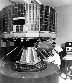
TIROS.
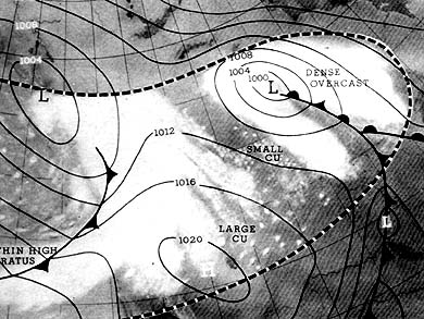
One of the first images returned (9 May 1960) by TIROS-1. Superimposed on the cloud patterns is a generalized weather map for the region.
TIROS (Television Infrared Observation System) was a long-running series of polar-orbiting meteorological satellites. It began with 10 experimental spacecraft, TIROS 1 to 10, launched between 1960 and 1965, which represented the first generation of American weather satellites. These carried low-resolution television and infrared cameras, and were developed by the Goddard Space Flight Center and managed by ESSA (Environmental Science Services Administration). Then followed the TOS (TIROS Operational System) consisting of nine satellites with the ESSA designation. This gave way to the ITOS (Improved TIROS), beginning with TIROS-M and continuing with five satellites of the same design with the NOAA (National Oceanic and Atmospheric Administration) designation-NOAA having by this time absorbed ESSA and taken over management of the TIROS program. Further upgrades have come in the form of the TIROS-N, introduced in 1978, and the Advanced TIROS-N, introduced in 1984. See also Nimbus.
TIROS 1–10, ESSA 1–2, and ESSA 9 were launched from Cape Canaveral, while ESSA 3–8, TIROS-M, TIROS-N, and NOAA 1–16 were launched from Vandenberg.
| series | spacecraft | launch date | launch vehicle | orbit | mass (kg) |
| TIROS | |||||
| TIROS 1 | Apr 1, 1960 | Thor-Able | 656 × 696 km × 48° | 120 | |
| TIROS 2 | Nov 23, 1960 | Delta | 547 × 610 km × 49° | 130 | |
| TIROS 3 | Jul 12, 1961 | Delta | 723 × 790 km × 48° | 129 | |
| TIROS 4 | Feb 8, 1962 | Delta | 693 × 812 km × 48° | 129 | |
| TIROS 5 | Jun 19, 1962 | Delta | 580 × 880 km × 58° | 129 | |
| TIROS 6 | Sep 18, 1962 | Delta | 631 × 654 km × 58° | 127 | |
| TIROS 7 | Jun 19, 1963 | Delta B | 338 × 349 km × 58° | 135 | |
| TIROS 8 | Dec 21, 1963 | Delta B | 667 × 705 km × 59° | 119 | |
| TIROS 9 | Jan 22, 1965 | Delta C | 701 × 2,564 km × 96° | 138 | |
| TIROS 10 | Jul 2, 1965 | Delta C | 722 × 807 km × 99° | 127 | |
| TOS | |||||
| ESSA 1 | Feb 3, 1966 | Delta C | 684 × 806 km × 98° | 138 | |
| ESSA 2 | Feb 28, 1966 | Delta E | 1,352 × 1,412 km × 101° | 132 | |
| ESSA 3 | Oct 2, 1966 | Delta E | 1,348 × 1,483 km × 101° | 145 | |
| ESSA 4 | Jan 26, 1967 | Delta E | 1,323 × 1,437 km × 102° | 132 | |
| ESSA 5 | Apr 20, 1967 | Delta E | 1,352 × 1,419 km × 102° | 145 | |
| ESSA 6 | Nov 10, 1967 | Delta E | 1,406 × 1,482 km × 102° | 132 | |
| ESSA 7 | Aug 16, 1968 | Delta N | 1,428 × 1,471 km × 101° | 145 | |
| ESSA 8 | Dec 15, 1968 | Delta N | 1,411 × 1,461 km × 102° | 132 | |
| ESSA 9 | Feb 26, 1969 | Delta E | 1,422 × 1,503 km × 101° | 145 | |
| ITOS | |||||
| TIROS M | Jan 23, 1970 | Delta N | 1,431 × 1,477 km × 101° | 309 | |
| NOAA 1 | Dec 11, 1970 | Delta N | 1,421 × 1,470 km × 101° | 306 | |
| NOAA 2 | Oct 15, 1972 | Delta 100 | 1,446 × 1,453 km × 102° | 344 | |
| NOAA 3 | Nov 6, 1973 | Delta 100 | 1,499 × 1,508 km × 102° | 345 | |
| NOAA 4 | Nov 15, 1974 | Delta 2914 | 1,442 × 1,457 km × 102° | 340 | |
| NOAA 5 | Jul 29, 1976 | Delta 2914 | 1,504 × 1,519 km × 102° | 340 | |
| TIROS-N | |||||
| TIROS N | Oct 13, 1978 | Atlas F | 829 × 845 km × 99° | 734 | |
| NOAA 6 | Jun 27, 1979 | Atlas F | 785 × 800 km × 99° | 723 | |
| NOAA 7 | Jun 23, 1981 | Atlas F | 828 × 847 km × 99° | 1,405 | |
| NOAA 12* | May 14, 1991 | Atlas E | 805 × 824 km × 99° | 1,416 | |
| Advanced TIROS-N | |||||
| NOAA 8 | Mar 23, 1983 | Atlas F | 785 × 800 km × 99° | 3,775 | |
| NOAA 9 | Dec 12, 1984 | Atlas E | 833 × 855 km × 99° | 1,712 | |
| NOAA 10 | Sep 17, 1986 | Atlas E | 795 × 816 km × 99° | 1,700 | |
| NOAA 11 | Sep 24, 1988 | Atlas E | 838 × 854 km × 99° | 1,712 | |
| NOAA 13 | Aug 9, 1993 | Atlas E | 845 × 861 km × 99° | 1,712 | |
| NOAA 14 | Dec 30, 1994 | Atlas E | 847 × 861 km × 99° | 1,712 | |
| NOAA 15 | May 13, 1998 | Titan II | 807 × 824 km × 99° | 1,476 | |
| NOAA 16 | Sep 21, 2000 | Titan II | 853 × 867 km × 99° | 1,476 |
N.b. NOAA 12 was launched out of sequence.

