
GEOS (Geodetic Earth Orbiting Satellite)
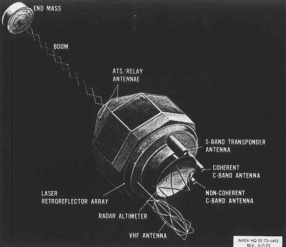
Labeled artist concept of GEOS-3GEOS 3.
GEOS (Geodetic Earth Orbiting Satellite) was a series of NASA spacecraft flown as part of the National Geodetic Satellite Program (NGSP). Instrumentation varied by mission, with the goals of pinpointing observation points (geodetic control stations) in a three-dimensional Earth center-of-mass coordinate system to within 10 m, determining the structure of Earth's gravity field to five parts in 10 million, defining the structure of Earth's irregular gravitational field and refining the locations and strengths of large gravity anomalies, and comparing results of the various systems onboard the spacecraft to determine the most accurate and reliable system.
GEOS 1 and 2 were part of the Explorer series and also designated Explorer 29 and 36. GEOS 3 was designed to be a stepping stone between the NGSP and the Earth and Ocean Physics Application Program by providing data to refine the geodetic and geophysical results of the NGSP. It proved important in developing gravity models before the launch of TOPEX/Poseidon since it was located near that spacecraft's mirror inclination.
| spacecraft | launch date | launcher | launch site | orbit | mass |
| GEOS 1 | Nov 6, 1965 | Delta E | Cape Canaveral | 1,114 × 2,273 km × 59.4° | 175 kg |
| GEOS 2 | Jan 11, 1968 | Delta E | Vandenberg | 1,079 × 1,572 km × 105.8° | 209 kg |
| GEOS 3 | Apr 9, 1975 | Delta 2918 | Vandenberg | 816 × 850 km × 115.0° | 341 kg |
 |
| GEOS-3 |

