
military reconnaissance and surveillance

Figure 1. Ground-based image of an EORSAT spacecraft.
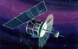
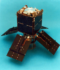
Figure 2. FLTSATCOM 1.
AFSATCOM
AFSATCOM (Air Force Satellite Communications System) is a satellite-based system that provides high-priority communications for command and control of American global nuclear forces. It became operational on 19 May 1979. AFSATCOM equipment rides piggyback on other military satellites, including, originally, FLTSATCOM satellites and, currently, Milstar satellites.
Almaz
Almaz was an ambitious, top-secret Soviet project envisioned by Vladimir Chelomei as a manned orbiting outpost equipped with powerful spy cameras, radar, and self-defense weapons.
ASAT
Main article.
An ASAT (antisatellite) is a satellite or other device whose purpose is to disable an enemy satellite.
Ballistic Missile Defense Organization
The Ballistic Missile Defense Organization (BMDO) was an American Department of Defense agency, formerly known as the Strategic Defense Initiative Organization (SDIO) and created in 1983 under the Reagan administration to develop an antiballistic missile defense, a major part of which would involve "Star Wars" weaponry based both on the ground and in space. Originally intended to counter the threat of Soviet intercontinental ballistic missiles, the SDIO was renamed the Ballistic Missile Defense Organization (BMDO) in 1993 under the Clinton administration. Its emphasis under the Bush (Jr.) presidency shifted to address similar threats from rogue nations with ballistic and tactical missile technology. Former SDI programs to develop Star Wars weapons, including ASAT (antisatellite) technology, continued and were emphasized by the Bush (Jr.) administration.
Canyon
Canyon was the first generation of large American SIGINT (signals intelligence) satellites and the first combined ELINT/COMINT satellites.
CERISE
 |
CERISE (Characterisation de l'Environment Radio-electrique par un Instrument Spatial Embarque) was an experimental ELINT (electronic intelligence) microsatellite built for the French arms procurement agency DGA (Delegation Generale pour l'Armement). It is notable for having suffered the first accidental collision between two independent orbiting objects. On 21 July 1995, a piece of debris from the Ariane 1 third stage that launched SPOT 1 in 1986 collided with CERISE. During the impact, the upper portion of CERISE's gravity-gradient boom was broken off. It was subsequently catalogued as space object 1995-033E. See also France in space.
| launch date | Jul 7, 1995 |
| launch vehicle | Ariane 5 |
| site | Kourou |
| orbit | 666 × 675 km × 98.1° |
| size | 60 × 35 × 35 cm |
| mass | 50 kg |
Chalet/Vortex
Chalet/Vortex was the second generation of United States Air Force SIGINT (signals intelligence) satellites, launched between 1978 and 1989, that superceded Canyon and Rhyolite/Aquacade.
COMINT
COMINT (communications intelligence) is a sub-category of SIGINT (signals intelligence) that involves messages or voice information derived from the interception of foreign communications.
Corona
Corona was America's first series of photo-reconnaissance or IMINT (image intelligence) satellites, involving more than 100 launches between 1959 and 1972.
Courier
Main article.
Courier was a United States Army experimental communications satellite.
DMSP
DMSP (Defense Meteorological Satellite Program) is the sixth generation of United States military weather satellites.
DSCS
DSCS (Defense Satellite Communications System) is the United States Department of Defense global network of strategic communications satellites.
Early warning satellite
An early warning (EW) satellite is a military spacecraft used to detect the launch of missiles and rockets from Earth's surface.
ELINT
ELINT (electromagnetic intelligence) is the interception and analysis of electromagnetic signals of other countries including radar, radio, telephony, and microwave transmissions. It can be carried out effectively using satellites. ELINT is a sub-category of SIGINT (signals intelligence).
EORSAT
EORSAT (ELINT Ocean Reconnaissance Satellite) is a system of specialized Russian/Soviet ELINT (electronic intelligence) satellites that became operational in 1978 following an initial launch in 1974 (Fig 1). It monitored and located enemy naval forces by detecting and triangulating on their radio and radar emissions. Each EORSAT consisted of a 3,1500-kg spacecraft with a 1.3-m diameter, 17.0-m-long cylindrical bus and two large solar arrays. A typical operational orbit was 404 kilometers by 417 km at an inclination of 65°. About 45 EORSAT spacecraft had been launched, by Tsylon 2 rockets from Baikonur, by the end of 2001.
FLTSATCOM
FLTSATCOM (Fleet Satellite Communications) is a constellation of American military satellites in geostationary orbit which, together with Leasats, supported worldwide, ultra-high-frequency (UHF) communications between naval aircraft, ships, submarines, and ground stations, and between the Strategic Air Command and the national command authority network (Fig 2). It became fully operational in January 1981 and was gradually replaced during the 1990s by satellites in the UFO (UHF Follow-On) series. An outgrowth of the LES (Lincoln Experimental Satellite) series and Tacsat 1, FLTSATCOM was developed by the Navy to be the first complete operational system in space to serve the tactical user. However, through special transponders carried aboard the satellites it also supported AFSATCOM (Air Force Satellite Communications System), which is a vital component of the American strategic nuclear capability.
GRAB
GRAB was the first series of American ELINT (electronic intelligence) satellites, operated by the United States Navy between July 1960 and August 1962.
Helios
Helios are advanced French optical military reconnaissance satellites based on SPOT 4.
IDCSP
The IDCSP (Initial Defense Communications Satellite Program) was the United States military's first near-geosynchronous satellite communications system. A total of 26 IDSCP satellites were launched between 1966 and 1968 in four groups by Titan IIICs to near-equatorial, 29,500-km-high orbits. Each weighed about 45 kg and drifted from west to east at a rate of up to 30° per day. IDCSP satellites transmitted reconnaissance photos and other data during the Vietnam War. When IDCSP reached initial operational capability, the system was renamed DSCS I (Defense Satellite Communications System I). It was succeeded by NATO and DSCS II true geosynchronous satellites in the 1970s.
IMEWS
IMEWS (Integrated Missile Early Warning Satellite) is a program of American military satellites designed to operate from geosynchronous orbit and detect launches of enemy intercontinental and submarine-launched ballistic missiles using infrared and optical sensors. Four were launched – the first unsuccessfully – by Titan IIICs in the early 1970s. The IMEWS program was a successor to MIDAS.
IMINT
An IMINT (imagery intelligence) satellite is a satellite that uses film and electronic cameras, or radar, to produce high-resolution images of objects on the ground at ranges of up to 1,000 km. Orbiting at altitudes of several hundred km, today's IMINT satellites can identify and distinguish different types of vehicles and equipment with a resolution of up to 10 cm. They are used both for peacetime collection of intelligence, including verification of arms control agreements, and the location of military targets to in wartime. The 1991 Gulf War was the first time that data returned from IMINT satellites directly supported combat operations. The first generation of IMINT satellites, known as Corona, returned high-resolution photographs to Earth via small reentry capsules. Film return satellites were superceded in the 1980s by electronic imaging satellites which return pictures to Earth via telemetry.
Jumpseat
Jumpseat were American military intelligence (NRO) satellites launched in the 1970s and early '80s into Molniya-type orbits. These orbits are very similar to those of SDS (Satellite Data System) classified communications satellites, and identification of a launch in either series as SDS or Jumpseat may differ. Jumpseat was associated with DSP. Its successor, known as Advanced Jumpseat, was associated with SBIRS.
Key Hole
Key Hole (KH) is the name used by the National Reconnaissance Office (NRO) for various series of US PHOTINT military reconnaissance satellites.
Lacrosse
Lacrosse was a series of American all-weather reconnaissance satellites.
Luch
Luch ('beam') satellites are an element of the second generation Soviet global command and control system, deployed in the first half of the 1980s. Analogous to the American TDRSS (Tracking and Data Relay Satellite System), they provided communications service to Mir, the Buran shuttle, Soyuz-TM spacecraft, military satellites, and the TsUPK ground control center. They also supported mobile fleet communications for the Soviet Navy. The modernized Luch-2 allows two high data rate channels to operate at once, enabling real-time TV transmissions from Mir. Each satellite is equipped with three transponders and has a nominal life of five years. By January 1999, five had been launched.
Magnum
Magnum was the code name for Shuttle-launched geostationary ELINT satellites designed to replace the Rhyolite/Aquacade series. After the second Magnum launch, in 1989, the code name was changed to Orion.
Mentor
Mentor is a fourth-generation ELINT (electronic intelligence) satellite launched for the CIA.
Mercury-ELINT
Mercury-ELINT were fourth generation United States Air Force ELINT (electronic intelligence) satellites, introduced in the late-1990s and designed to pick up a wide spectrum of electromagnetic energy for use in broadband monitoring. Unlike most other ELINT satellites, which operate in geosynchronous orbits, Mercurys are placed in even higher orbits and move in complex, elliptical patterns. This not only gives them wider coverage but also allows them to
MIDAS
MIDAS (Missile Defense Alarm System) was a largely-unsuccessful system of United States military early-warning satellites launched between 1960 and 1966.
Milstar
Milstar (Military Strategic and Tactical Relay satellite) is a series of advanced American military satellites designed to provide survivable, global jam-resistant communications for command and control of strategic and tactical forces through all levels of conflict.
NRO
The NRO (National Reconnaissance Office) is a United States Department of Defense agency, formed in 1961, which designs, builds, and operates American reconnaissance satellites. President Dwight Eisenhower stepped up the development of spy satellites in the wake of the Soviet Union's shooting down of a U-2 spy plane, piloted by Gary Powers, in 1960. NRO satellites are used by the CIA (Central Intelligence Agency) and other members of the American intelligence community. In recent years, NRO has declassified some of its earlier missions, including the 1960–1972 Corona photoreconnaissance operation. In December 1996, NRO also gave, for the first time, advance notice of the launch of one its spacecraft. In September 2011, NRO declassified the KH (Key Hole) -7 (Gambit 1), -8 (Gambit 3), and -9 (Hexagon) satellites.
Ofeq
Main article.
Ofeq is a series of Israeli indigenous satellites
Orlets
The Orlets series are Russian photo-reconnaissance satellites similar to the Yantar type but carrying a small amount of onboard propellant for maneuvering. They also use a film-return capsule mechanism with 22 separate capsules. These features extend the mission duration of an Orlets satellite to between six months and a year.
Parus
The Parus satellites form a network of military satellites which, for a quarter of a century, has provided navigational information and store-dump radio communications for Russian/Soviet naval forces and ballistic missile submarines. Being the operational successor to Tsyklon, Parus is also known as Tsyklon-B. Flight trials of the new satellites began in 1974 and the system was accepted into military service in 1976. From 1974 to the present, there have been about 90 launches in the series, all by Cosmos-3M rockets from Plesetsk, into roughly circular orbits with an altitude of about 1,000 km and an inclination of 83°.
PHOTINT
PHOTINT is an acronym for 'photographic Intelligence.'
Potok
Potok is an element of the second generation Soviet global command and control system. Potok satellites are integrated with the Luch system – the latter handling communications between spacecraft and ground stations, the former handling communications between fixed points and digital data from the Yantar-4KS1 electro-optical reconnaissance satellite. About 10 Potoks have been placed in GSO between 1982 and the present by Proton-K launch vehicles from Baikonur.
reconnaissance satellite
A reconnaissance satellite, also known as a spy satellite, is an Earth observation satellite or communications satellite used for military or intelligence operations.
Rhyolite/Aquacade
Rhyolite/Aquacade was a series of United States SIGINT (signals intelligence) satellites placed in quasistationary orbits in the 1970s to intercept, for example, telemetry in radio nets controlling the flight of Soviet bombers. Rhyolite satellites were also used to spy on communications during local conflicts in Vietnam, and also between India and Pakistan. When the project's code name was revealed during the espionage trial of Boyce and Lee – the "Falcon and the Snowman" – it was subsequently (from Rhyolite 3 on) changed to Aquacade. The Rhyolite/Aquacades had a similar configuration to Canyon, except that their receiving antenna had a diameter of 20 m, and they had more than doubled in weight to 680 kg. There were four Rhyolite launch attempts between 1970 and 1978, all successful.
Romb
The Romb series are subsatellites, released by Soviet Taifun spacecraft, to enable the calibration of air and space defense radars. Their name means "rhombus."
Samos
Samos was a series of American military spacecraft launched in the early 1960s to carry out global television surveillance from polar orbits.
SBIRS
SBIRS (Space-Based Infrared System) is a successor to the DSP (Defense Support Program) system of satellites.
SB-WASS
SB-WASS (Wide Area Surveillance Satellite)) was a series of ELINT (electronic intelligence) satellites developed by the United States Navy. Each SB-WASS consists of a primary infrared-scanning satellite and a triplet of associated drone craft. Triangulation, together with the known time lag between the satellites, enables the exact location of a target to be determined. Weapons targeting data are then sent from the SB-WASS to air and ground controllers by laser communications.
SDIO
SDIO (Strategic Defense Initiative Organization) was a United States Department of Defense body formed in Apr 1984 to develop a space-based missile defense system. SDIO was renamed the Ballistic Missile Defense Organization (BMDO) in 1993. It has been involved with a number of space missions, including Clementine and various Shuttle-launched payloads.
SIGINT
SIGINT (signals intelligence) satellites are reconnaissance (spy) satellites that intercept communications, radar, and other forms of electromagnetic transmissions. ELINT (electronic intelligence) and COMINT (communications intelligence) satellites are sub-categories.
| Chronology of American SIGINT satellites | |||||
|---|---|---|---|---|---|
| 1st generation 1960s |
2nd generation 1970s |
3rd generation 1980s |
4th generation 1990s |
5th generation 2000+ |
|
| GEO-USAF COMINT | Canyon | Chalet/Vortex | Mercury-ELINT | ||
| GEO-CIA ELINT | Rhyolite/Aquacade | Magnum/Orion | Mentor | Intruder | |
| HEO-USAF ELINT | Jumpseat | Trumpet | Prowler | ||
| LEO-USAF ELINT | Ferret | Subsats | Subsats | SB-WASS | |
| LEO-Navy ELINT | GRAB | NOSS | NOSS | SB-WASS |
SSF
SSFs (subsatellite ferrets) were classified United States Air Force subsatellites, released in association with other military launches, that carried out radio and radar signals intelligence gathering. There have been several types, dating back to the 1963 "Hitch Hiker" spacecraft, but details remain secret.
surveillance satellite
A surveillance satellite is a military spacecraft that provides reconnaissance data in the form of high-resolution visible, infrared, or radar imagery.
Taifun
Taifun are second-generation Soviet target and surveillance satellites used for testing air defense and space tracking systems. The Taifun-1 series consisted of nearly 40 spacecraft launched from the mid-1970s onward. Taifun-2 satellites, of which some 30 were launched between 1976 and 1995, differed from their predecessors in the type of equipment carried and also in the fact that they released up to 25 Romb subsatellites. All the Taifun spacecraft were placed into low Earth orbits of high inclination using Kosmos-3M launch vehicles from Plesetsk and Kaputsin Yar.
Trumpet
Trumpet is a series of fourth-generation United States Air Force signals intelligence satellites equipped with a large deployable mesh antenna. They operate from Molniya-type orbits and are designed to monitor Soviet communications and missile tests. The first were launched in the mid-1990s.
Tselina
Tselina was a series of Russian ELINT (electronic intelligence) satellites, the first of which was launched on 26 June 1967; Tselina means "untouched soil." There were two basic types. Tselina I was used mostly for tracking NATO shipping. Similar to the American SB-WASS system, it operated in a constellation that detected ELINT data and then compared readings from different locations over time to pinpoint the position of the source. It then transmitted weapons targeting data, relayed by communications satellites either to ground stations or directly to Russian ships. Tselina II was a more general-purpose system, similar to Mercury-ELINT.
Yantar
Yantar is a series of Soviet and Russian photo-reconnaissance satellites. Scores of Yantars (their name means "amber") were launched in the 1970s and 1980s. However, the Russian photo-reconnaissance satellite program has been running at a low level in recent years, with only one launch in 1999 and three in 2000.
Currently three types of Yantar are flown. The close-look Yantar-4K2s, code-named Kometa, have three reentry vehicles: two small film-return capsules that can return data while the main satellite continues to operate in orbit, and a conical main descent module that is recovered with the camera system and remaining film at the end of the mission. Yantar-1KFTs, code-named Kometa, carry out missions to update topographic and mapping data maintained by the Ministry of Defense. The operational lifetime of satellites like Kometa and Kobalt are limited by the amount of film they can carry. However this limitation is overcome with the Yantar-4KS1 Neman satellites. These return images digitally via radio link, either direct to Russian controllers when passing over Commonwealth of Independent States territory or via data relay satellites in the Potok system which are in geosynchronous orbit. With Neman, the lifetime is limited by the amount of propellant carried for orbital maneuvering. A fourth type of photo-reconnaissance satellite presently used by Russia is the Orlets-2. Unlike the 6.6–7 ton Yantar-class satellites which are launched by Soyuz-Us, the 12-ton Orlets requires the much larger Zenit-2.

